This segment of The Nordland trekking trail is a total of 85.7 km. Due to good road connections along this segment, it can be completed as three separate trips:
Ny-Sulitjelma to Skaiti
Skaiti to Graddis
Graddis to Lønsdal
You can hike the entire segment by taking a train to Fauske, then a bus to Sulitjelma at the northern starting point, and finally, take a train from Lønsdal at the southern endpoint.
This part mostly traverses valleys and partly high mountain terrain at an altitude between 5–600 meters above sea level. The initial section follows the west and north sides of Balvatnet. Large portions of the route pass through Junkerdal National Park.
21. section. Ny-Sulitjelma fjellstue - Lomivatnet (4,4 km)
Hiking description
The hike starts down Hankenlia along the construction road. Just under 100 meters before reaching Lomiveien, the T-marked trail turns left. It follows upwards along the base and south side of Tverrfjellet and northeast of the watercourse flowing from Lomivatnet. The trail traverses gently undulating terrain. There is also a construction road from Hankelia to Lomivatnet. From the road, it's about 0.5 km to the cabin.
There are several abandoned mines in the area. In Sulitjelma (Fagerlia), there is a mining museum. The last shift in the mine ended in 1991.
Jakobsbakken on the other side of the Sulitjelma valley is a well-preserved mountain mining town, with visible traces of mining. There are companies here that offer accommodation and activities.
In the town of Sulitjelma, there is a shop and a hotel.
In the town, you can see remnants of the old railway and old buildings from the mining era.
The Lomi watercourse is regulated.
22. section. Lomivatnet - Tjálanisjávrre (12,8 km)
Hiking Description
From Lomihytta, the trail heads west for approximately 0.5 km until it meets the construction road. This is followed southwards on the west side of Lomivatnet/Loamejávrre until reaching the end of the road in Fagerlibukta. Here, a marked trail continues diagonally up the slope southwestward, passing by lake 856 on the northwest side. The trail then continues through undulating mountain terrain to Kong Oscar-vatnan (southeast of Tjålbbe - 891 meters above sea level). The lake is rounded on its southeast side before gradually descending towards the tree line and circling down to Tjalalveshytta. Midway, there is a junction leading northward. This is an alternative trail that leads to Sulitjelma.
The final part of the route passes through Junkerdal National Park.
King Oscar (1799-1859) has given his name to both the lake and mountains along the route.
23. section. Tjálanisjávrre – Tjoarvihytta (11,7 km)
Hiking Description
From the northeast end of Tjálanisjávvre and Tjoarvihytta, the trail exits the birch forest and ascends diagonally approximately 200 meters up the slope towards the southwest until passing between elevation 768 meters in the north and 860 meters in the south. This is directly south of Syrvatnet. The trail then descends slightly and continues through gently undulating terrain until reaching the northwest end of Littj-Dorro/Vuolep Doarrojávrre. Here, the outlet is crossed via a bridge. The trail then heads south along a ridge west of Littj-Dorra before turning west and descending into the valley between Duolbbavárddo (867 meters above sea level) in the south and Jåttuvarre in the north (769 meters above sea level). There is a crossing trail that is followed northward for 6-700 meters before heading northwest to a new junction. The trail follows a small valley and passes on the north side of two small lakes before descending, meeting the birch forest, and descending to Tjoarvihytta.
Try your luck fishing in the many mountain lakes along the route.
There are often reindeer in the area.
The first and last parts of the hike are within Junkerdal National Park.
24. section. Tjoarvihytta - Ballvatnet (17,8 km)
Hiking Description
Follow the road from the cabin northward until the trail veers west just after you enter Balvassveien. The outlet of Ner-Tjorvi is crossed via a bridge. After crossing the bridge, turn right heading south and follow the trail up 200 meters in elevation until it passes south of Jámekjávrás. The trail continues southwest through gently undulating terrain until it crosses the Rosna River between Nedre-Rosna in the north and Fuglvatnet in the south. The river is crossed via a bridge. The trail then continues westward before, after passing the southern end of Mariavatnet, turning southward towards the northwest end of Ballvatnet. From there, the trail follows the southwest side of Ballvatnet for 7 kilometers to the Balvasscabins. Just before reaching the cabins, the outlet is crossed via a bridge.
The Rosna lakes, Fuglvatnet, and Daudvatnet are considered good fishing lakes.
The route passes by Nordland's only palsmyr (Pals are mounds or ridges on a bog, over one meter high, containing a core of permafrost. The ground freezes below the groundwater level.)
There are often reindeer in the area. Large parts of the route are within Junkerdal National Park.
25. section. Ballvatnet - Argaladhytta (9,2 km)
Hiking Description
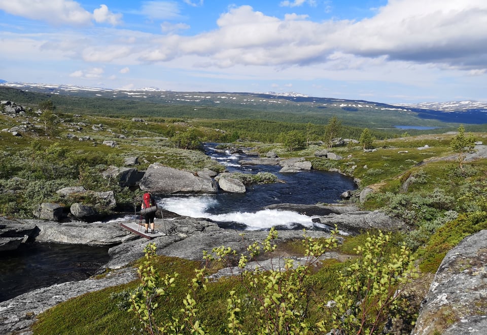
From Balvasshytta, backtrack approximately 1 km and cross the bridge over the outlet of Ballvatnet. After crossing the bridge, the trail heads south through Skiejdevággi and along Skaitielva/Skiejddejåhkå. Arggalájtjåhkkå (1566 m above sea level) looms to the south of the valley, while Salfjellet/Sála (1400 m above sea level) dominates the northern side. Approximately one kilometer before reaching the cabin, Arggalájåhkå is crossed via a bridge.
From Argaladhytta, the trail continues southward through Skiejdevággi and along Skaitielva/Skiejddejåhkå. It begins along the southwest bank, but after about 2.5 km, the river is crossed via a bridge, and the trail continues along the northwest side of the river all the way to Trygvebu. The trail passes through forested terrain with Tausafjellet to the south and Slájppá to the north.
The first part of the hike passes through Junkerdal National Park
The rapids and currents of Skaitielva
Hiking through lush nature
27. section. Skaiti - Graddis (7,8 km)
Hiking Description
From Trygvebu, follow the road downhill past the farmstead (recreational property) and parking lot. Cross Skaitelva via a bridge and follow the road uphill to the junction at Austerås. Continue up the road for a short distance before it enters the terrain as a trail. The route continues southeast before crossing Skaitiveien and turning south down steep terrain until it crosses the RV77 (national road). Then proceed downhill to cross the Knallerdalselv/Skærrimjåhkå river on a bridge and continue over the Graddiselva/Graddasjåhkå river to Graddis Mountain Lodge.
Metusalem - an old pine tree that was once 18 meters tall and had a diameter of 3.45 meters at breast height. The tree was protected in 1910, and it is said to be over 1000 years old. The tree stands along the Nordlandsruta between Knallerdalselva and Graddiselva.
The hike starts by following the road 3-400 meters west from Graddis Mountain Lodge. Here, the trail turns left and heads up the hillside. After passing under the power line, the trail ascends diagonally up the slope to Rundbjerkhaugen (634 meters above sea level) and then to Litlfjell (725 meters above sea level) before flattening out and heading towards the north side of Austre Viskisvatnet/Lulep Visskisjávrre. You are now in the Saltfjellet Landscape Protection Area. Before Flatviskis, there are several trail intersections, but Nordlandsruta should be followed westward at all intersections. From here, the trail descends to the north side of Vestre Viskisvatn/Alep Viskisjávrre before crossing the outlet of the lake via a bridge. The trail continues westward through gently undulating terrain in the Dypen Nature Reserve until reaching Lønselva/Luonsojåhkå. This river is crossed via a bridge. Follow the E6 southward for a few hundred meters and then take the road towards Lønsdal station. Lønsstua is located south of the road, uphill towards the station.