This segment of the The Nordland trekking trail is a total of 95.0 km and mostly traverses Sweden. The initial section are also part of the Padjelantaleden trail. This segment passes through Padjelanta National Park, which is a part of the Laponia World Heritage Area. The route concludes on the southern Norwegian side, where the second-highest mountain in Northern Norway, Suliskongen (1908 meters above sea level), and the third-highest, Dama (1781 meters above sea level), dominate the landscape to the southeast in the Bremassivet mountain massif. On the northern side of the route, Blåmannsisen stands tall. This segment of the The Nordland trekking trail primarily traverses high mountain terrain at an altitude between 600 and 800 meters above sea level.
Hiking description
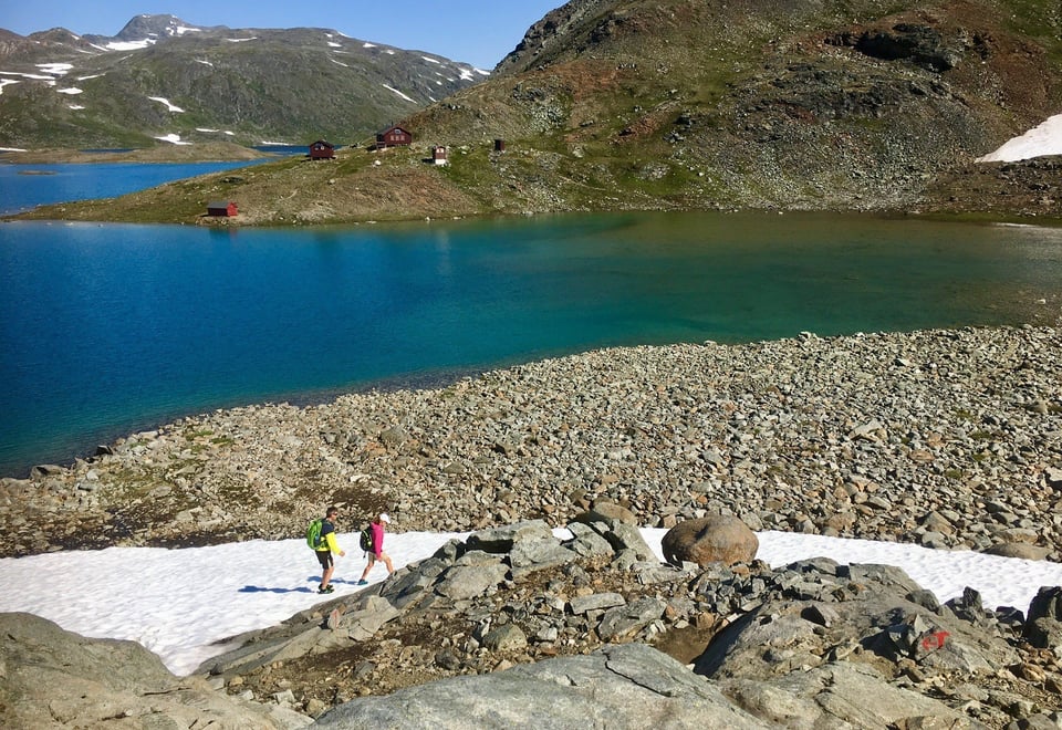
13. section. Vájsáluokta – Kutjaure (15,3 km)
Hiking description:
The first part of the section follows the shore of Akkajaure towards the southeast. This section is very rocky, so it may be worthwhile to walk along the beach. After about 2 km, you will reach the Sámi village of Vájsáluokta, one of Sweden's largest. Here, you will pass by two beautiful Sámi turf huts. The trail crosses the Sjváltjàjåhkå river on a bridge. After the bridge, the trail turns up the somewhat steep slope to the south. After climbing about 100 meters in altitude, you leave the birch forest behind and look out over the wide U-shaped valley with 1100-1200 meter high peaks on each side. The trail follows the east side of Guossjájåhkå. The river has several impressive waterfalls. After passing on the east side of Guossjájávrre, you reach the highest point of the stage, and just before reaching Gårssåjávrre, there is an emergency shelter cabin. After passing to the east of Gårssåjávrre, the trail crosses the outlet on a bridge before descending the slope. When you reach the birch forest, it is not far to STF Kutjaure Mountain Hut.
You can find a map of the stage HERE. (Scroll down to the map and zoom in).
Experiences along the way:
Visit to the Sámi village in Vájsàluokta. If you're lucky, you can buy Sámi handicrafts here.
From Vájsàluokta, you can rent a boat across Akkajaure to Ritsem.
Visit to the turf huts in Vájsàluokta.
Waterfalls along the Guossjájåhkå river.
Views over the inland lake Akkajaure.
Birdlife around the mountain lakes.
Limestone formations near the bridge over the outlet of Gårssåjávrre.
14. section. Kutjaure - Låddejåhkå (17,2 km)
Hiking description:
After leaving STF Kutjaure Mountain Hut, the trail heads southward over a bridge spanning Sieberjåhka. From the bridge, you can overlook the river's waterfalls, across Kutjaure, and towards Stora Sjöfallets National Park with its highest peak, Áhkká (2011 meters above sea level). At the bridge, you can also observe some potholes. Once you've crossed Sieberjåhka, you've entered Padjalanta National Park. It's not permitted to bring dogs into the park.
Continuing southward, the trail passes through an open flat area called Skädda (meaning large reindeer herd) before reaching a reindeer fence just before the watercourse Varggá. Initially, you cross the watercourse on a 60-meter-long suspension bridge, then pass over a small peninsula, then over a shorter bridge to an islet in the watercourse, and finally cross The Nordland Trekking Trail's longest suspension bridge, which is 100 meters long. After crossing the bridges, the trail continues southward along the east side of Vuojatädno, ascends about 200 meters in altitude before rounding the west side of Loadásj (995 meters above sea level), passing a reindeer fence, and finally descending 200 meters in altitude to Låddejåhkå. Along this section, you'll enjoy great views of Vastenjaure, Pajalanta's second-largest lake. Just before the cabin, another reindeer fence is passed.
You can see a map of the stage HERE (scroll down to the map and zoom in).
Experiences along the way:
Sieberjåhka's waterfalls and fascinating potholes.
Views of several Sámi villages Scenic views over Padjalanta's second-largest lake, Vastenjaure.
Birdlife along Låddejåhkå (bird creek).
15. section. Låddejåhkå - Árasluokta (12,6 km)
Hiking description:
The hike begins a few hundred meters up along Låddejåhkå before crossing it on a bridge. Take a moment on the bridge to admire the rushing waterfall and look for potholes and stunning rock formations along the river. From the bridge, the trail ascends 250 meters over approximately five kilometers of uphill terrain. Just before reaching the highest point of the trail, the path passes by a peculiar rock formation, about two meters high. The trail then traverses through the mountain pass of Pårka/Boarkka before descending along a four-kilometer stretch down to Miellädno. The river is crossed on a bridge before rounding on the west side and foot of Áras (897 meters above sea level) to reach Árasluokta. This location is situated at the eastern end of a bay in Virihaure with the same name.
You can see a map of the stage HERE (scroll down to the map and zoom in).
Experiences along the way:
Låddejåhkå's waterfall, rock formations, and potholes
The rock formation named "Pårkagubben" (The Old Man of Pårka). Legend has it that this is a troll turned to stone, unable to reach its destination before the arrival of the spring sun.
A metal cross is erected just south of Miellädno. This serves as a memorial to an unknown man who escaped from a Russian prisoner camp in Norway during World War II.
Views over Virihaure, which is Padjelanta's largest lake
Visit to Árasluokta Sámi village and examine a "njalla" (traditional Sámi storage hut) built there.
16. section. Árasluokta - Stálouokta (10,1 km)
Hiking description:
The section begins on a bridge over the short stretch of river flowing into Virihaure from Luoppal. The trail rounds the southwest side of Luoppal and proceeds through gently rolling terrain until it reaches the eastern end of a bay in Stáddajåkha, where the Viejejåhka river is crossed on a bridge over a 10-meter-high gorge. From here, the trail follows the river in varying terrain. Behind us, we have a beautiful view of Virihaure, while ahead, we see the broad valley between Jållevarre (1113 meters above sea level) to the east and Gáhpesoajvve (1257 meters above sea level) to the west that must be traversed. The landscape is characterized by numerous gravel mounds and ridges formed during the last ice age. Before reaching Gáhpesluoppal, the trail passes the river delta of the Jiegnáffojåhkå river. It can be challenging to navigate the river channels here, especially early in the spring. The final stretch follows the west bank of Gáhpesluoppal to the cabins located on the south side of Stáddàjåhkå.
You can see a map of the stage HERE (scroll down to the map and zoom in).
Experiences along the way:
Crossing the bridge over Viejejåhka where the river flows fiercely through a 10-meter-high gorge. Take the time to visit the potholes by the river on the south side of the bridge.
Close encounters with gravel mounds and ridges formed during the last ice age.
This section offers excellent opportunities to see reindeer.
Numerous traces of past reindeer husbandry activities are recorded along the trail.
17.section. Stálouokta - Stáddájåhkå (11,9 km)
Hiking description:
The section begins on a bridge over the short stretch of river flowing into Virihaure from Luoppal. The trail rounds the southwest side of Luoppal and proceeds through gently rolling terrain until it reaches the eastern end of a bay in Stáddajåkha, where the Viejejåhka river is crossed on a bridge over a 10-meter-high gorge. From here, the trail follows the river in varying terrain. Behind us, we have a beautiful view of Virihaure, while ahead, we see the broad valley between Jållevarre (1113 meters above sea level) to the east and Gáhpesoajvve (1257 meters above sea level) to the west that must be traversed. The landscape is characterized by numerous gravel mounds and ridges formed during the last ice age. Before reaching Gáhpesluoppal, the trail passes the river delta of the Jiegnáffojåhkå river. It can be challenging to navigate the river channels here, especially early in the spring. The final stretch follows the west bank of Gáhpesluoppal to the cabins located on the south side of Stáddàjåhkå.
You can see a map of the stage HERE (scroll down to the map and zoom in).
Experiences along the way:
Crossing the bridge over Viejejåhka where the river flows fiercely through a 10-meter-high gorge.
Take the time to visit the potholes by the river on the south side of the bridge. Close encounters with gravel mounds and ridges formed during the last ice age.
This section offers excellent opportunities to see reindeer.
Numerous traces of past reindeer husbandry activities are recorded along the trail.
18. section. Stáddájåhkå - Sårjåsjávrre (5,4 km)
Hiking description
The trail starts from the cabins at the outlet of Stáddájåhkå and goes approximately one kilometer up along the river until it reaches a suspension bridge. Here, there is a trail junction where one path (the Nordkalottleden) continues southward along the river towards Pieskehaurestugan, while Nordlandsruta crosses the river on the bridge and heads west. When you leave the bridge, you also leave Padjelanta National Park. After two kilometers, the trail comes close to Sårjåsjohkå. The path continues on the south side of the river and up to Sårjåsjávrre and to the cabin located right by the outlet of the lake.
You can see a map of the stage HERE (scroll down to the map and zoom in).
Experiences along the way
Take a break on the suspension bridge over Stáddájåhkå and admire the rushing river flowing down the mountain steps.
Experience the close proximity to Sårjåsjohkå's waterfalls, rapids, and fascinating cliffs.
Snow often remains along the trail well into the summer.
Views towards the Bré Massif.
19. section. Sårjåsjávrre – Bajep Sårjåsjávrre (11,8 km)
Hiking description
This section begins along the southern shore of Såråsjávrre and follows the shoreline for 4 kilometers to the Norwegian border. This section of the trail is somewhat poorly marked, and the marshes are not bridged. Further on, the trail is marked with T-signs and easy to follow. You'll need to cross a river fed by glacial meltwater from the Sulitjelma massif to the south. The bridge over the river is destroyed, so you'll have to ford the river closer to Sårjåsjávrre. The trail then continues along the southwest side of the lake, rounding the base of the mountain before reaching the southeast end of Bajep Sårjåsjávrre. The name means the higher-lying Såråsjávrre and is located 4 meters higher. In the final part of the stage, the trail follows the shoreline to the Sorjus cabins.
The color of the waters can almost be described as turquoise.
On a small islet at the eastern end of Bajep Sårjåsjávrre, you can see a large split rock towering in the landscape.
Hiking in borderland.
20. section. Bajep Sårjåsjávrre - Ny-Sulitjelma fjellstue (10,7 km)
Hiking description
The trail rounds the bay south of the Sorjus cabins. During heavy snowmelt, expect to ford several small rivers. The river coming down from lake 859 is crossed on a bridge, followed up the slope on the west side before crossing the river again on a bridge and passing lake 859 on the east side. The trail then rounds up the slope and the foothills on the west side of the high peaks in the Sulis massif. You'll pass a height between 1048 meters to the west and 1058 meters to the east before the trail descends to the east side of Bajep Sårjåsjárásj. From here, the trail goes over the hill to the south before descending diagonally down the approximately 200 meters in altitude to the east side of the regulated Storelvvatnan/Duolldagåptåpjávrre. This is rounded up the slope and gently ascends before crossing two rivers flowing into Storelvatnan. These must be forded. From here, the trail traverses gently undulating terrain towards the western tip of Tverrfjellet. To the east lies the Sulis massif with its beacon peak (1715m), Stortoppen (1822m), and Kokedaltinden/Duolldagåpjåhkkå (1470m). The final part rounds diagonally down the western side of Tverrfjellet and descends to Hankelila. A construction road winds down the slope west of the trail.