Is there a difference between blue and red trail markings? And what does the red T mean? Here you will find an explanation of the different trail and route markings used by The Norwegian Trekking Association (DNT).
The Norwegian Trekking Association maintains more than 23,000 kilometers of marked summer trails across Norway. In addition, about 6,400 kilometers of winter routes are marked for skiing. With so many markings, it can sometimes be confusing to know which ones to follow.
Below you will find an explanation of how DNT marks trails and routes, so you know what to look for when hiking in forests, mountains, and coastal areas — both in summer and winter.
Why should you follow marked trails and routes?
Following a marked trail, path, or route reduces the risk of getting lost. This is especially important in the mountains, where fog and storms can appear suddenly.
Trail markings also help channel foot traffic, which protects vegetation and wildlife by keeping hikers on designated routes.
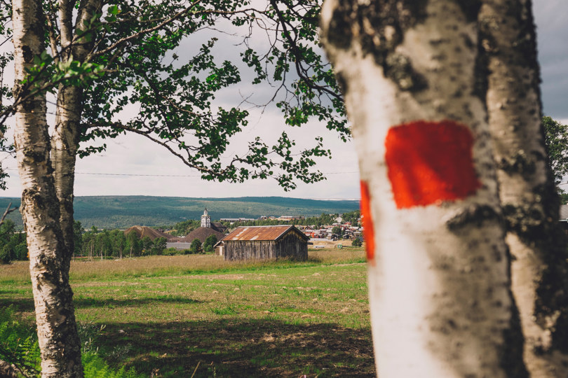
In contiguous forest areas, the hiking trails are marked in blue. In forests that lead up into the mountains, it is more common to have red markings on the trees as well. Photo: Marius Dalseg
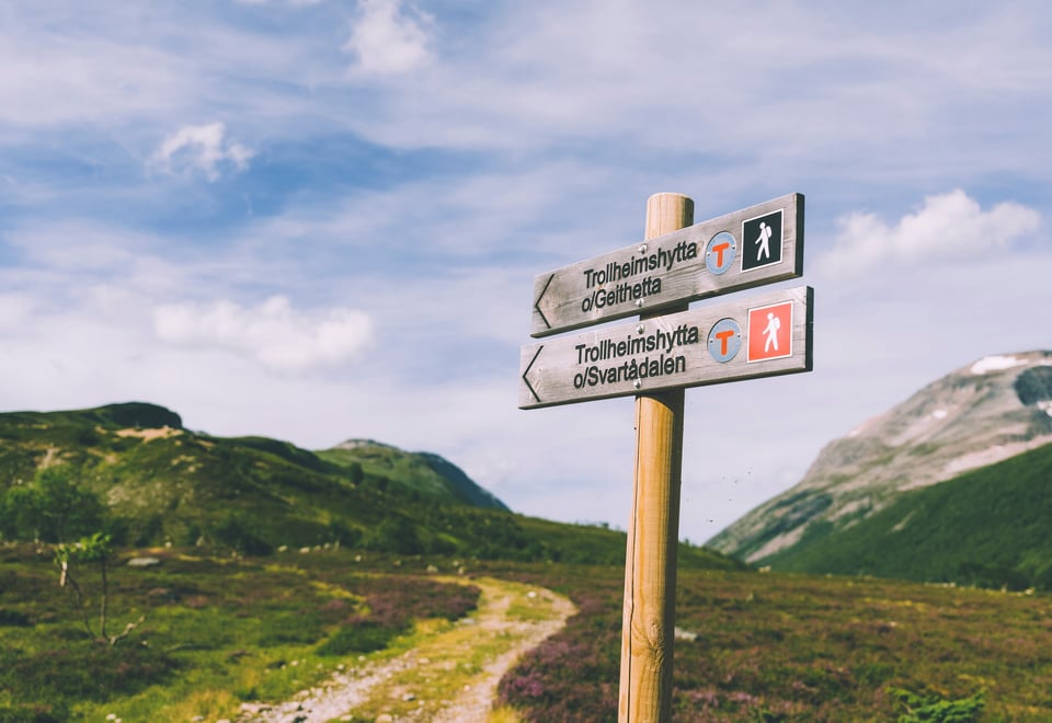
Marking in the forest and on the coast
Many hikers have ended up with wet feet because they accidentally followed the wrong markings in the forest. The explanation below will hopefully help you avoid that and keep your hike dry and enjoyable.
Summer marking
Trails intended for summer hiking are marked in blue. These markings can be painted on trees, rocks, or signposts.
Winter marking
Ski routes are marked in red, which can be confusing because people often associate red with summer trails and blue with winter routes.
If you follow winter markings during summer, you may end up in marshes or wet terrain that are only suitable for skiing when frozen.
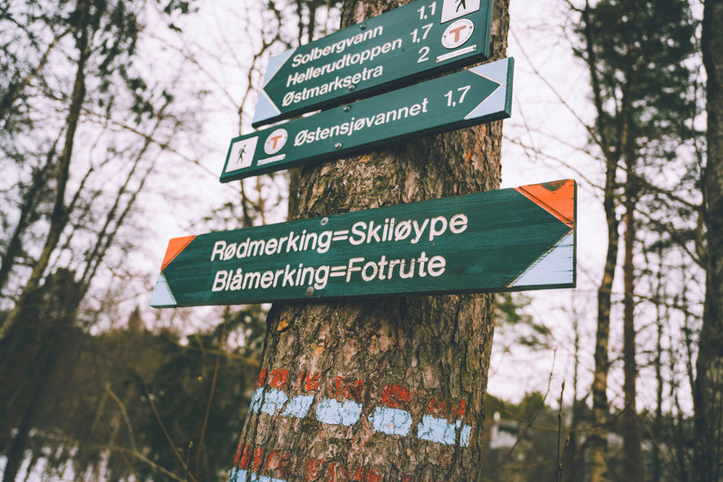
The Marking Handbook
The Marking Handbook establishes a national standard for marking hiking routes throughout Norway.
It is published jointly by The Norwegian Trekking Association, the Norwegian Coastal Association, and the Norwegian Association of Outdoor Councils.
All DNT routes must follow these standardized marking guidelines.
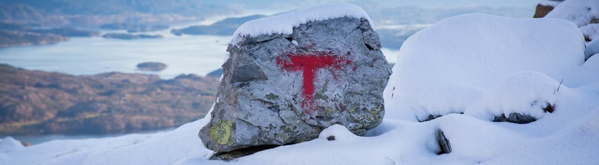
A red-marked tree on the Ore Route that goes from Røros, over the mountains and into Femundsmarka. Photo: Marius Dalseg
Marking in the mountains
As a general rule, paint markings should not be applied directly to rock or bedrock. Therefore, mountain routes are usually marked with small cairns (stone piles).
One advantage of cairns is that they can easily be removed if a trail needs to be rerouted or closed.
To indicate that a route is maintained by DNT, some cairns are marked with a red T. The red color is highly visible, even in foggy or grey weather.
It is important not to build your own cairns (so-called “wild cairns”), as they can mislead hikers and create dangerous situations when visibility is poor.
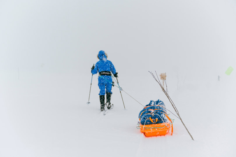
Winter marking and "limbing"
In winter, the most frequently used mountain routes in southern Norway are marked with birch branches or poles (“limbing”) placed in the snow. These indicate ski routes across open terrain where normal trail markers are not visible.
Trail markings are not equally consistent everywhere. This may happen for several reasons:
It may have been a long time since the trail was last maintained.
Markings may be spaced farther apart in some areas.
Some markings are not placed by DNT and may vary in quality.
Regardless of trail markings, you should always carry a map and compass, even in areas you know well. This is especially important in poor visibility, when navigation skills are necessary to stay on route.
Summer and winter marking
All routes and paths that either go through forest to the mountains or are in mountainous areas have red markings. This avoids a color change when the same route crosses the tree line.
For winter routes in the mountains, limbing is often used, since deep snow or lack of vegetation makes other marking methods impossible.
An overview of all DNT's trails and routes can be found on UT.no
Where the snow lies for a long time during the summer, it can hide the cairns. Large snow patches that lie all summer can make it impossible to mark close enough that you can see from cairn to cairn.
In fog or poor visibility, the route markings may be impossible to see, which makes a map, compass, or GPS essential.
When crossing glaciers, you may see tracks in the snow that look safe to follow. However, you should never follow glacier tracks without proper equipment, rope, and glacier knowledge, as they may pass over hidden crevasses.
Year-round and summer bridges
Bridges are an important aid to getting places. But some bridges only exist in the summer.
Most bridges are mentioned in the route descriptions on UT.no. They are either permanent year-round bridges or summer bridges. Where we do not know what type of bridge it is, it only says bridge.
Summer bridge
The summer bridges are dismantled in the autumn and set up when the snow has melted in the summer the following year.
Usually this happens when the serviced cabins in the area open. Snow that hides the bridge abutments can delay the laying in some years. The summer bridges are often taken down when the serviced cabins close in the autumn.
Year-round bridge
Year-round bridges are left outside through the winter. If you use a map from the hover series Norway 1:50,000, all bridge signs are year-round bridges.
Also on these maps, there may be bridges that are missing and drawn bridges that have disappeared.
DNT's member associations with cabins in the area can often answer which bridges are taken in in the autumn. The status of the bridges can change over time.
When the bridges are not in place, it can mean that it becomes impossible to follow the routes in the area because the rivers cannot be passed. On newer hiking maps, the summer and year-round bridges are usually shown with their own signs, but the bridges along the paths are not always marked.