Where can the avalanche occur, and how far can they travel? If you are planning ski touring in the backcountry, you must be able to recognize avalanche terrain. This guide outlines the level of avalanche knowledge required for touring in simple, challenging, and complex terrain.
Published: April 20, 2026 Written by:
Håvard Engen, Fjellsportgruppa i Trondhjems Turistforening
Inspiration
In this article, you will find an overview of the recommended competence for each terrain class, along with key concepts you need to understand before touring marked routes in winter.
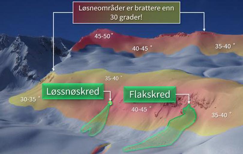
Slab avalanches are the most dangerous. They typically release on slopes steeper than 30° and can propagate over large areas.
Loose snow avalanches usually start at a single point and are generally smaller but can still be hazardous in steep terrain.
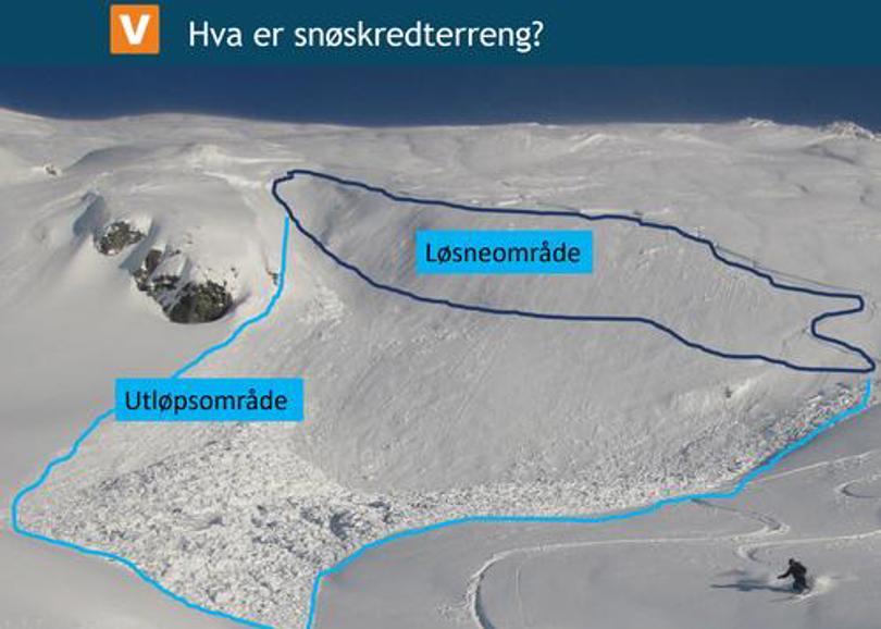
Slopes steeper than 30° are referred to as starting zones (release areas). From there, avalanches can travel downslope into runout zones, which may be much flatter.
Together, starting zones and runout zones form what we call avalanche terrain. Being able to identify both on a map and in the field is a minimum requirement for safe winter travel outside marked trails.
Simple terrain is open and easily navigated and only occasionally has steep sections so that it is possible to completely avoid starting zones. Only in exceptional cases do you need to cross runout areas, and there are few terrain traps. For most skiers in the mountains, this is the favorite terrain that offers an incredible number of opportunities both on backcountry skis and traditional mountain skis.
As mentioned above, you must still be able to identify the steepness around you so that you can avoid avalanche terrain.
Recommended group size is from 1 to 16.
Even if you do not intend to move into the avalanche terrain, it is a good habit to check the regional avalanche forecast on Varsom.no, it will give you information about the snow conditions and mountain weather and useful knowledge if you later want to seek out more demanding terrain. Even here, there will be terrain around 30 degrees that you can choose to seek out or avoid.
You can learn the basic avalanche knowledge through ski touring and gaining experience from experienced and knowledgeable skiers, read about avalanches in books and online and to take a one-day course avalanches or even better a basic avalanche course (grunnkurs skred) with the quality stamp of NF - Norwegian Mountain Sports Forum.
On the next level, there is challenging terrain. Here you get the avalanche terrain closer to you often combined with terrain traps. Here you have to make active choices to avoid exposure to these. At the same time, you can also choose to hike or ski in steeper areas, but this requires that you can assess and verify the stability of the snow, through the use of the avalanche warning on the varsom.no and the traffic advice there and continuous collection of information from the snow as you go.
In any case, remember that the avalanche warning applies to an entire region and that there may be local variations that the forecast is unable to capture and predict.
In order for the avalanche forecast and touring advice to make sense, you must learn what they mean through the avalanche school at varsom.no and through attending an avalanche course. You will receive training in this at an NF basic avalanche course. To become even better at making your own assessments, you can also excel with NF advanced avalanche course.
The third and most demanding terrain class is called complex terrain. Here, the terrain is both steep and complex with many terrain traps and few or no safe areas outside avalanche terrain. Here you also start from the avalanche forecast and the touring advice on varsom.no. At the same time you must be able to make independent assessments of the snowpack and the avalanche risk where you are and where you are going.
In addition, it will require a lot from everyone in the ski touring group both in terms of terrain and snowpack understanding, skiing technique, and most importantly how you communicate and make decisions. You must therefore be a knowledgeable skier with lots of experience from ski touring in in easier terrain classes before approaching complex terrain.
We recommend that before you set off in complex terrain as a minimum, you have completed an NF advanced avalanche course and gained a lot of practical experience in less demanding terrain than this.